
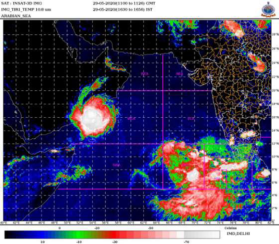
PIB News Update: According to the National Weather Forecasting Centre of the India Meteorological Department: Latest satellite imageries indicate that the well marked Low pressure area over west central Arabian Sea off south Oman & east Yemen coasts has concentrated into a depression over south coastal Oman and adjoining Yemen and lay centred at 1430 hrs IST of today, the 29th May, 2020 near latitude 17.5°N and longitude 54.0°E, about 50 km north of Salalah (Oman) and 240 km northeast of Al Ghaydah (Yemen). It is very likely to intensify further into a deep depression during next 12 hours. It is very likely to move north-northwestwards during next 24 hours and west-southwestwards thereafter.
Warnings:
(i) Rainfall:
- No adverse weather is likely over the Indian land areas, with the first system, as it is located over south coastal Oman and is expected to move over Oman and Yemen during next 48 hours and dissipate there.
(ii) Wind warning
- Squally wind speed reaching 45-55 kmph gusting to 65 kmph very likely to prevail over westcentral Arabian Sea along & off South Oman – Yemen coasts during next 48 hours.
(iii) Sea condition:
- The sea condition is very likely to be rough to very rough over westcentral Arabian Sea along & off South Oman – Yemen coasts during next 48 hours.
(iv) Fishermen Warning:
- The fishermen are advised not to venture into over westcentral Arabian Sea along & off South Oman–Yemen coasts during next 48 hours.
- In view of the likely development of the second low pressure system over southeast & adjoining eastcentral Arabian Sea, Fishermen are advised not to venture into southeast and adjoining east-central Arabian Sea from 31st May, until further advisories.
According to the IMD:
♦ The Southwest Monsoon advanced into some parts of southwest and southeast Arabian Sea and some more parts of Maldives-Comorin area. Conditions are
becoming favourable for further advance of Southwest Monsoon into some more parts of south Arabian Sea, Maldives-Comorin area, southwest and southeast Bay of Bengal during next 48 hours.
♦ Meanwhile, under the influence of a Western Disturbance and an east-west trough in lower tropospheric levels, rain/thunderstorm accompanied with lightning, hail & squall at isolated places have occurred over Western Himalaya Region & adjoining plains during last 24 hours. As a result, maximum temperatures over plains of north India and central & west India have fallen by 3-4°C during past 24 hours. Maximum temperatures over Uttar Pradesh, north Haryana and north Punjab have fallen by 5-7°C during past 24 hours.
Scattered to fairly wide spread rain/thunderstorm accompanied with lightning, hail & squall at isolated places likely to continue over Western Himalaya Region & adjoining plains during next 3 days and reduce significantly thereafter.
♦Heat wave conditions abated from most parts of the country yesterday except Telangana & Vidarbha. No heat wave condition likely to develop over any parts of country during 30th May to 2nd June.
♦ Heavy rainfall very likely at isolated places over parts of south peninsular India during 29th-31st May, 2020 with isolated Heavy to Very Heavy Rainfall over
Kerala, Coastal Karnataka & south Interior Karnataka during 29th-31st May and over Lakshadweep during 30th May- 01st June 2020.