
PIB News Update: According to the National Weather Forecasting Centre/Regional Meteorological Centre, New Delhi of the India Meteorological Department (IMD):
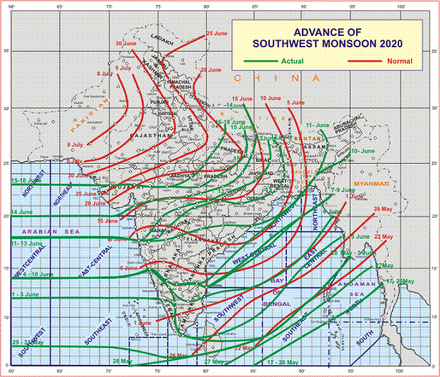
- Under favourable meteorological conditions, there had been steady progress of Southwest Monsoon during the past week (11th-16th) and southwest monsoon has covered entire Northeast & East India, most parts of West and Central India and some parts of Uttar Pradesh during this period. The Northern Limit of Monsoon (NLM) passed through Lat.23°N/Long.60°E, Kandla, Ahmedabad, Indore, Raisen, Khajuraho, Fatehpur, Bahraich and Lat.28°N/Long.81.5°E on 16th June 2020 and it remained at the same position till today 18th June 2020 (Annexure I).
- Due to present meteorological scenario, the Southwest Monsoon is not likely to progress further till 21st June 2020. Conditions are likely to become favourable thereafter for further advance of southwest monsoon into some more parts of Uttar Pradesh and some parts of Western Himalayan Region during 22nd to 24th June 2020.
- Southwest Monsoon is likely to reach Haryana including National Capital Region (Delhi-NCR) around 25th June 2020.
- During the course of progress of Southwest Monsoon, fairly widespread to widespread rainfall/thundershowers with isolated heavy falls likely over Uttar Pradesh, Uttarakhand, and Himachal Pradesh during 22nd to 24th June 2020.
♦ The Northern Limit of Monsoon (NLM) continues to pass through Kandla, Ahmedabad, Indore, Raisen, Khajuraho, Fatehpur and Bahraich.
♦ A trough runs from central Pakistan to Manipur at lower tropospheric levels and a cyclonic circulation lies over Jharkhand & neighbourhood at lower & midtropospheric levels. Under the influence of these systems and its oscillation, widespread rainfall with isolated heavy to very heavy rainfall very likely to continue over east & northeast India during next 5 days. Isolated extremely heavy is also likely over Sub-Himalayan West Bengal & Sikkim and Meghalaya on today, the 18 June, 2020. Central India is also very likely to experience fairly widespread to widespread rainfall activity with isolated heavy to very heavy falls over East Madhya Pradesh & Chhattisgarh during next 5 days.
♦ Light isolated to scattered rain/thunder shower very likely over northwest India except Uttrakhand (where, fairly widespread rainfall with isolated heavy falls is likely) during next 4-5 days.
♦ Due to likely dry northwesterly winds at lower tropospheric levels over most parts of Rajasthan, heat wave to severe heat wave conditions very likely over Rajasthan during next 2-3 days.
Annexure I
Kindly visit www.imd.gov.in for updates. For further details and forecast updates kindly visit websites of IMD, New Delhi:
http://www.imd.gov.in/pages/allindiawxfcbulletin.php