
Summary:Researchers say aerial images taken from drones or helicopters are just as accurate as more conventional field methods used for estimating river discharge.
With an ever-growing human population and its inherent demand for water, there is a critical need to monitor water resources. New technology could make it more feasible than ever to measure changes in the water flow of rivers.
Tyler King and Bethany Neilson, researchers at Utah State University, have developed a new method to estimate river discharge using aerial imagery gathered from helicopters and drones. Their new study, published Feb. 7 in Water Resources Research, found that aerial imaging can be just as accurate as older, more expensive field methods in some cases.
These alternative methods for monitoring water resources are necessary to continue meeting global water demands while simultaneously easing the impacts of floods and droughts.
“We are headed into uncharted territory as climate change alters water supply and population growth increases demand,” said Tyler King, a PhD candidate and co-author of the study. “In the face of these challenges, scientists, engineers and managers around the world are asked to perform the increasingly difficult task of managing water resources with less and less information.”
There are a limited and dwindling number of locations where river discharge is measured directly at gauging stations. Establishing and maintaining these stations is expensive and time consuming. As a result, preference is often given to large rivers of significant economic and social importance. Additionally, other remote sensing methods have been developed, but rely on relatively coarse data collected by satellites and, as such, also focus on the larger rivers of the world. As a result, scientists lack a complete view of what is happening in smaller river basins, leaving limited understanding of the processes controlling river water quantity and quality.
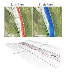
King and Neilson’s approach aims to fill this data gap by using high resolution aerial imagery to estimate flows at many locations along smaller rivers and streams. This complements both traditional gauging station networks that are tied to a limited number of specific locations along river networks and satellite based remote sensing methods that are used to estimate flows in larger rivers.
Their basic approach uses a unique combination of image processing techniques and hydraulic modeling that limits the amount of data required to estimate river discharge. Their method overlaps aerial images to produce three-dimensional digital elevation models of the river channels. This information is then used within a hydraulic model to approximate the relationship between river discharge and river width. Once these models are built, any following observations of river width — including satellite imagery, aerial imagery or ground observations — can be used to estimate river discharge.
“Remote sensing methods like these can significantly improve our ability to understand hydrologic responses to a changing climate in small, ungauged watersheds around the world,” said Neilson, an associate professor at USU and co-author of the study.
More:Science Daily