
PIB News Update: According to the Cyclone Warning Division of the India Meteorological Department (IMD):
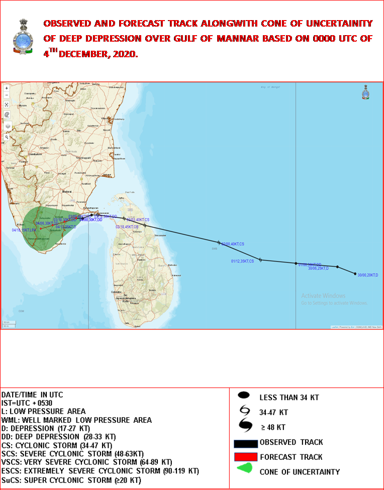
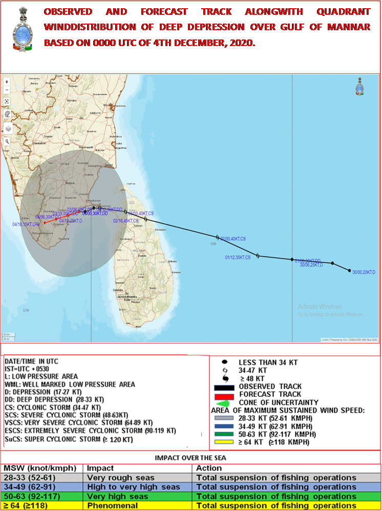
Deep Depression over Gulf of Mannar
The Deep Depressionover Gulf of Mannarclose to Ramanathapuram District coast remained practically stationaryduring past three hours and lay centered at 0530 hrs IST of 04thDecember over Gulf of Mannar near Lat. 9.1°N and Long. 78.6°E close to Ramanathapuram District coast,about 40 km southwest of Ramanathapuram, 70 km west-southwest of Pamban and 160 km northeast of Kanniyakumari. The associated wind speed is about 55-65 gusting to 75 kmph.
The Deep Depression likely to move slowly west-southwestwards and cross Ramanathapuram and adjoining Thoothukudi districts during next 06 hours with wind speed of 50-60 gusting to 70 kmph. It is very likely to weaken further into a Depression (wind speed 45-55 kmph gusting to 65 kmph) during next 12 hours.
Forecast track and intensity are given below:
| Date/Time(IST) | Position (Lat. 0N/ long. 0E) | Maximum sustained surface wind speed (Kmph) | Category of cyclonic disturbance |
| 04.12.20/0530 | 9.1/78.6 | 55-65 gusting to 75 | Deep Depression |
| 04.12.20/1130 | 9.0/78.2 | 50-60 gusting to 70 | Deep Depression |
| 04.12.20/1730 | 8.9/77.8 | 45-55 gusting to 65 | Depression |
| 04.12.20/2330 | 8.8/77.4 | 25-35 gusting to 45 | Low Pressure Area |
Warnings:
(i) Rainfall
· Heavy to very heavy rainfall at a few places very likely over south Tamilnadu and at isolated places over Kerala & Mahe during next 24 hours. Heavy to very heavy rainfall at isolated places very likely over north Tamilnadu, Puducherry & Karaikalduring next 24 hours.
· Heavy rainfall at isolated places very likely over south Coastal Andhra Pradesh and Lakshadweep on 04th December.
| Sub-Divisions | 04 Dec 2020* |
| South Tamilnadu | Rainfall at most places with heavy to very heavy falls at a few places |
| North Tamilnadu, Puducherry & Karaikal | Rainfall at many places with heavy fall at isolated places |
| Kerala & Mahe | Rainfall at many places with heavy to very heavy rainfall at isolated places |
| South Coastal Andhra Pradesh | Rainfall at a few places with heavy rainfall at isolated places |
| Lakshadweep | Rainfall at most places with heavy to very falls at isolated places |
(ii) Wind warning
- Squally wind speed reaching 55-65 kmph gusting to 75 kmph is very likely during next 06 hours along and off south Tamilnadu coast (Ramanathapuram, Thoothukudi, Tirunelveli and Kanniyakumari districts) and it will gradually decrease to 45-55 kmph gusting to 65 kmph by evening of 4th December.
- Squally wind speed reaching 35-45 kmph gusting to 55 kmph very likely to prevail along & off south Kerala coast (Thiruvananthapuram, Kollam, Pathanamthitta and Alappuzah districts) during next 24 hours.
- Squally wind speed reaching 35-45 kmph gusting to 55 kmph very likely over Lakshadweep-Maldives area and adjoining southeast Arabian Sea during next 24 hours.
(iii) Sea condition
- Sea condition is rough to very rough over Gulf of Mannar and adjoining southwest Bay of Bengal, along & off south Tamilnadu, west Sri Lanka coasts during next 12 hours and rough to very rough over Comorin Area, adjoining southeastArabian Sea and along & off Kerala coast by evening of 4th December.
(v) Fishermen warning and Action suggested
- Fishermen are advised not to venture into Gulf of Mannar and adjoining southwest Bay of Bengal and along & off south Tamilnadu coast and north Sri Lanka coasts during next 12 hours and along and off Kerala coast, Lakshadweep-Maldives area & adjoining southeast Arabian Sea during next 24-hours.
Kindly visit www.rsmcnewdelhi.imd.gov.in and www.mausam.imd.gov.in for updates on the system
Kindly download MAUSAM APP for location specific forecast & warning, MEGHDOOT APP for Agromet advisory and DAMINI APP for Lightning Warning.