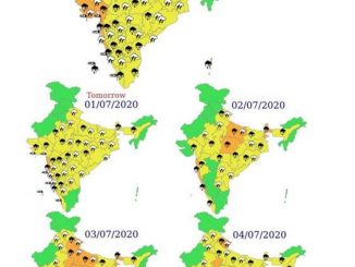
PIB News Update: According to the National Weather Forecasting Centre/Regional Meteorological Centre, New Delhi of the India Meteorological Department (IMD):
• The, southwest Monsoon has further advanced today into remaining parts of Kutch & Gujarat Region and Madhya Pradesh, some parts of Rajasthan, Chandigarh, North Punjab, most parts of Uttar Pradesh, Himachal Pradesh and entire Uttarakhand and Jammu & Kashmir, Ladakh, Gilgit-Baltistan & Muzaffarabad.• The Northern Limit of Monsoon (NLM) passes through Jaisalmer, Pali, Sawai Madhopur, Mainpuri, Bijnor and Pathankot.• Conditions have become favourable for further advance of southwest monsoon into some more parts of Rajasthan, remaining parts of Uttar Pradesh, Delhi, most parts of Haryana and Punjab during next 24 hours.
Current Meteorological Conditions
- A cyclonic circulation lies over northeast Rajasthan at lower tropospheric levels.
- Another cyclonic circulation lies over northeast Madhya Pradesh at lower tropospheric levels.
- A trough runs from northwest Rajasthan to south Bihar at lower tropospheric levels.
Forecast & Warnings
- Light/moderate fairly widespread to widespread rainfall with isolated heavy to very heavy rainfall very likely over Western Himalayan Region and Punjab, Haryana, Chandigarh & Delhi, West Uttar Pradesh and East Rajasthan during next 48 hours and intensity & distribution likely to decrease thereafter.
- Light to modearte fairly widespread to widespread rainfall activity with isolated heavy to very heavy falls also very likely over East Uttar Pradesh during next 4-5 days.
- Due to northward shift of eastern side of east-west trough across east & northeast India and convergence of strong southerly/south-westerly winds from Bay of Bengal over northeast & adjoining east India, fairly widespread to widespread rainfall with isolated heavy to very heavy rainfall very likely to continue over northeast India, Sub-Himalayan West Bengal & Sikkim and Bihar during next 4-5 days. Isolated extremely heavy rainfall is also likely over Sub-Himalayan West Bengal & Sikkim and Bihar during 25th-26th June and over Assam & Meghalaya during 24th-27th June, 2020.
[Note: * Rainfall till 0830 IST of next day.
Legends:
Heavy rain: 64.5-115.5 mm/day; isolated rain (≤25% of stations gets rain), scattered or at a few places rain (26 to 50% of stations gets rain), at many places or fairly widespread rain (51–75% of stations gets rain) and at most places or wodespread rain (>75% of stations gets rain)]
Advance of southwest Monsoon
Kindly visit www.imd.gov.in for updates.


Leave a Reply
You must be logged in to post a comment.