
PIB News Update: According to the National Weather Forecasting Centre/Regional Meteorological Centre, New Delhi of the India Meteorological Department (IMD):
A) Weather Systems:
· A Low Pressure Area is very likely over Northeast Bay of Bengal by tomorrow, the
20th September, 2020. It is likely to become more marked over Northwest Bayof Bengal during subsequent 24 hours.
· Strengthening of lower level winds and its convergence along the west coast is also
likely to continue during next 3-4 days.
· Convergence of strong moist winds in lower tropospheric levels from Bay of Bengallikely over northeast and adjoining parts of east India from 21st September onwards.
B) Weather Forecast & Warnings:
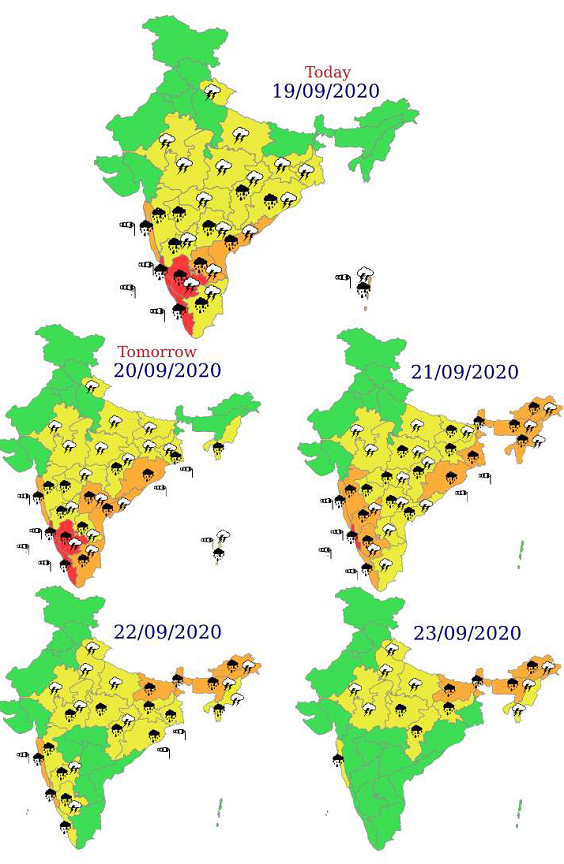
(i) Fairly widespread to widespread rainfall with isolated heavy to very heavy falls very
likely over Kerala, Karnataka and Konkan & Goa during 19th-22nd September. Isolated
extremely heavy falls also very likely over Coastal Karnataka during 19th-21st; over
north Kerala &Ghat sections of South Interior Karnataka on 19th & 20th; oversouth Konkan & Goa on 21st & 22nd September, 2020.
(ii) Fairly widespread to widespread rainfall with Isolated heavy to very heavy falls
likely over Andaman & Nicobar Islands on 19th & 20th; over Odisha, Coastal Andhra
Pradesh &Yanam and Telangana during 19th-21st and over Gangetic West Bengalduring 20th-22nd September, 2020.
(iii) Fairly widespread to widespread rainfall with isolated heavy to very heavy falls alsolikely over Sub-Himalayan West Bengal & Northeastern state during 21st-23rd
September. Isolated extremely heavy falls also likely over Arunachal Pradesh and
Assam & Meghalaya on 22nd and over Sub-Himalayan West Bengal & Sikkim on
22nd & 23rd September, 2020.
C) Impact expected over Coastal Karnataka during 19th-21st; over north Kerala andGhat sections of South Interior Karnataka and on 19th & 20th; over south Konkan &Goa on 21st & 22nd September, 2020 due to likely isolated extremely heavy falls:
· Localized Flooding of roads, water logging in low lying areas and closure of underpassesmainly in urban areas of the above region.
· Occasional reduction in visibility due to heavy rainfall.
· Disruption of traffic in major cities due to water logging in roads leading to increased
travel time.
· Minor damage to kutcha roads.
· Possibilities of damage to vulnerable structure.
· Localized Mudslides.
· Damage to horticulture and standing crops in some areas due to inundation.
· It may lead to riverine flooding in some river catchments (for riverine flooding please visitwebsite of Central Water Commission (http://www.cwc.gov.in/))
- For specific district wise impact kindly visit IMD’s sate level meteorological center
websites (https://mausam.imd.gov.in/imd_latest/contents/departmentalweb.php) and national website (https://mausam.imd.gov.in/).
D) Action Suggested:
· Check for traffic congestion on your route before leaving for your destination.
· Follow any traffic advisories that are issued in this regard.
· Avoid going to areas that face water logging problem often.
· Avoid staying in vulnerable structure.
Multi-hazard weather warning for next 5 days
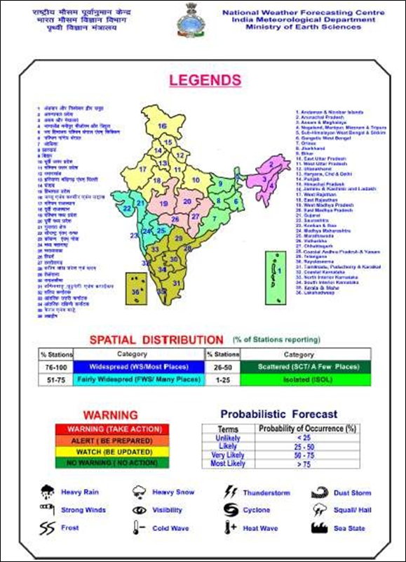
Legends: Heavy rain: 64.5-115.5 mm/day;
Very heavy rain: 115.6-204.4 mm/day;
Extremely heavy rain: Greater or equal to 204.5 mm/day
For further details and forecast updates kindly visit websites of IMD, New Delhi:http://www.mausam.imd.gov.in
For district level warning, kindly visit website of Meteorological Centres/Regional Meteorological Centres of IMD at statelevels.
Kindly download MAUSAM APP for location specific forecast & warning, MEGHDOOT APP for Agromet advisory and DAMINI APP for Lightning Warning.