PIB News Update: Scientists and students from Wadia Institute of Himalayan Geology (WIHG), an autonomous institute under the Department of Science &Technology,Govt. of Indiastudied rivers in Ladakh Himalaya, bringing out 35 thousand-year history of river erosion and identified hotspots of erosion and wide valleys that act a buffer zones. The study showed how rivers in drier Ladakh Himalaya operated in longer time scales and how they responded to varying climate, an understanding of water and sediment routing,which is crucial as the country gears up its infrastructure and develops smart cities.
The scientists have traced where the rivers draining Himalaya and its foreland erode the most and identify the zones that receive these eroded sediments and fill up. The Ladakh Himalaya forms a high altitude desert between Greater Himalayan ranges and Karakoram Ranges. The Indus and its tributaries are major rivers flowing through the terrain. The Zanskar River is one of the largest tributaries of the upper Indus catchment, draining orthogonally through highly deformed Zanskar ranges.Two prominent tributaries of Zanskar River are the Doda and TsrapLingti Chu, which confluence at Padam village in the upper valley to form the Zanskar River.
In the study published in the journal Global and Planetary ChangesZanskar catchment was explored by WIHG team to understand the landform evolution in transitional climatic zone, using morpho stratigraphy and provenance study of landforms like valley fill terraces, alluvial fans(triangle-shaped deposit of gravel, sand, and even smaller pieces of sediment, such as silt).
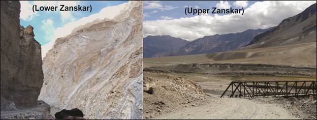
Their research suggested that the wide valley of Padam, with an area of 48 square km, in the upper Zanskar, has stored a vast amount of sediments in these landforms. Where, presently, 0.96±0.10 km3 of sediment is stored in its terraces and fans, and since the last 32 thousand years, 2.29±0.11 km3 of sediment has been eroded by the river from Padam, giving it a specific sediment yield of 2.2×10³ tons/km2 per year.
The sediment contribution from such transient basins is significant when compared with the 4–7 km3 of sediment reportedly eroded from the entireIndus system in Ladakh since the Last Glacial Maximum (LGM) and the 7–22 km3 from the Zanskar since last 10 thousand years. ThusPadam valley is a hotspot of sediment buffering in the Zanskar.A study of the sediments suggested that most sediments were derived from Higher Himalayan crystalline that lie in the headwater region of Zanskar. It was found out that dominant factors responsible for sediment erosion were deglaciation and Indian Summer Monsoon derived precipitation in the headwaters despite the presence of a geomorphic barrier (the deep, narrow gorge) between the upper and lower catchments of the river, and it remained connected throughout its aggradation history.
The study by the WIHG team will help to understand river-borne erosion and sedimentation, which are the main drivers that make large riverine plains, terraces, and deltas that eventually become the cradle to evolving civilizations.
Link to study: https://doi.org/10.1016/j.gloplacha.2019.04.015
Figure caption;
Zanskar river makes a deep gorge in its lower reaches with the headwaters in upper Zanskar makes wide basin called as Padam. The basin stores large amount of sediments in form of fans and river terrace deposits


